
This protocol was created in collaboration with the Natural History Institute of Iceland
|
How long does it take?
About 90 minutes Who is it for?
Materials:
Where and when?
|
Protocol (with approximate times):
1. Walking to the beach 2. What are we doing today? Why? (10 minutes)
| ||||||||
Shore zonation sheets
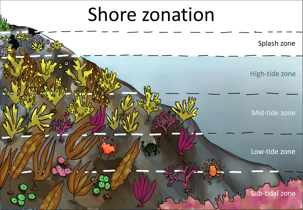
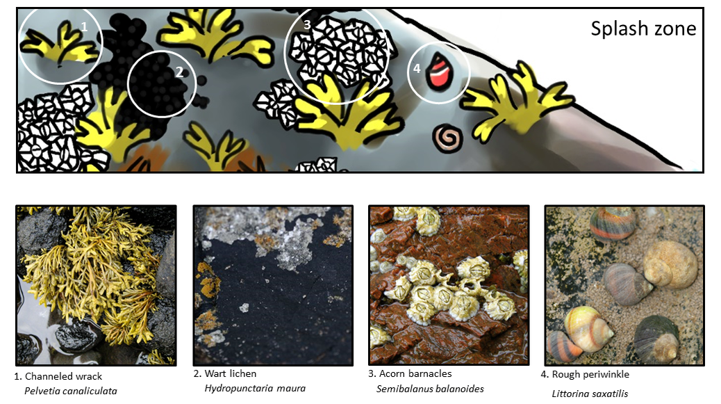
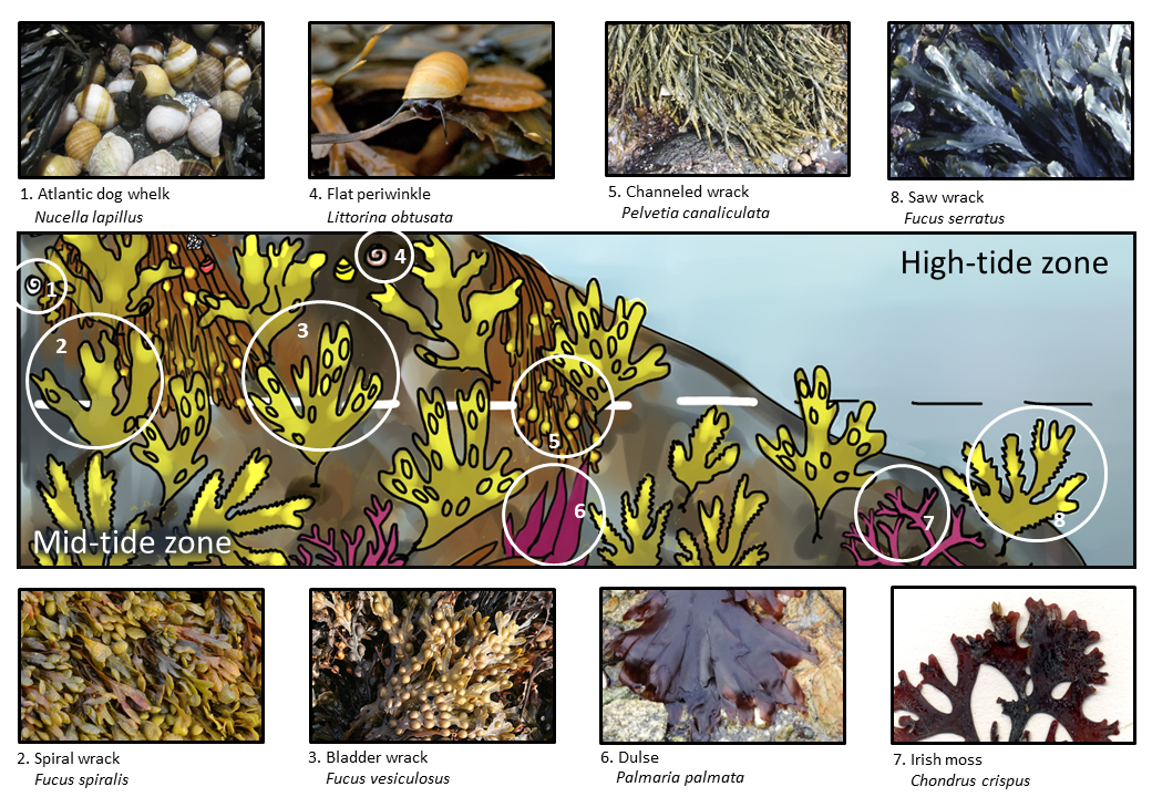
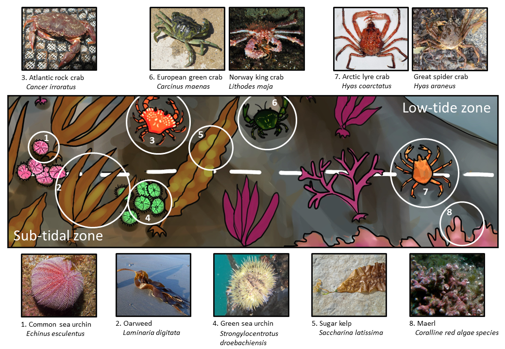
Photo credits
"Seaweed" by nothing is licensed under CC BY-NC 2.0.
Splash zone
1. "Chanelled Wrack (Pelvetia canaliculata)" by swan-scot is licensed under CC BY-NC-ND 2.0.
2. "Hydropunctaria maura" by thomasschreiter is licensed under CC BY-NC 4.0.
3. "Acorn Barnacles (Semibalanus balanoides)" by swan-scot is licensed under CC BY-NC-ND 2.0.
4. "Rough Periwinkles (Littorina saxatilis)" by S. Rae is licensed under CC BY 2.0.
High-tide and mid-tide zones
1. "Nucella lapillus" by BrentMWilson is licensed under CC BY-NC-SA 2.0.
2. "Fucus spiralis" by Hans Hillewaert is licensed under CC BY-NC-ND 2.0.
3. "File:Bladder Wrack (Fucus vesiculosus) - geograph.org.uk - 224125.jpg" by Anne Burgess is licensed under CC BY-SA 2.0.
4. "Littorina obtusata" by Sergey Yeliseev is licensed under CC BY-NC-ND 2.0.
5. "Ascophyllum nodosum" by bstarzomski is licensed under CC BY-NC 4.0.
6. "Palmaria palmata" by jaro is licensed under CC BY-NC 4.0.
7. "Chondrus crispus Helgoland" by Gabriele Kothe-Heinrich is licensed under CC BY-SA 3.0.
8. "Fucus serratus. Breaksea Point, October 1982" by Mary Gillham Archive Project is licensed under CC BY 2.0.
Low-tide and sub-tidal zones
1. "Oursin melon (Echinus esculentus)" by cquintin is licensed under CC BY-NC 2.0.
2. "Laminaria digitata" by mainebirder is licensed under CC BY 4.0.
3. "Cancer irroratus" by BrentMWilson is licensed under CC BY-NC-SA 2.0.
4. "Strongylocentrotus droebachiensis" by lauracgoetz is licensed under CC BY-NC 4.0.
5. "Saccharina latissima" by eagleloft is licensed under CC BY-NC 4.0.
6. "Caranguejo-verde (Carcinus maenas)" by Emerging Birder is licensed under CC BY-NC-SA 2.0.
"Lithodes maja" by viktorvg is licensed under CC BY-NC 4.0.
7. "Hyas coarctatus Leach, 1815" by IMARES is licensed under CC BY-NC-SA 4.0.
"Hyas araneus" by msciamanda is licensed under CC BY-NC 4.0.
8. "Fal and Helford Maerl Beds" by naturalengland is licensed under CC BY-NC-ND 2.0.